 by IntelliMass
Remote Asset & Corridor Intelligence
Dated, geolocated visual records of the infrastructure you can't get to often enough.
A vehicle drives the corridor. We turn that drive into a permanent record you can review from your desk, every point, every pass, compared over time.
Rights-of-way · access roads · haul roads · trails · pipelines · perimeters · egress routes
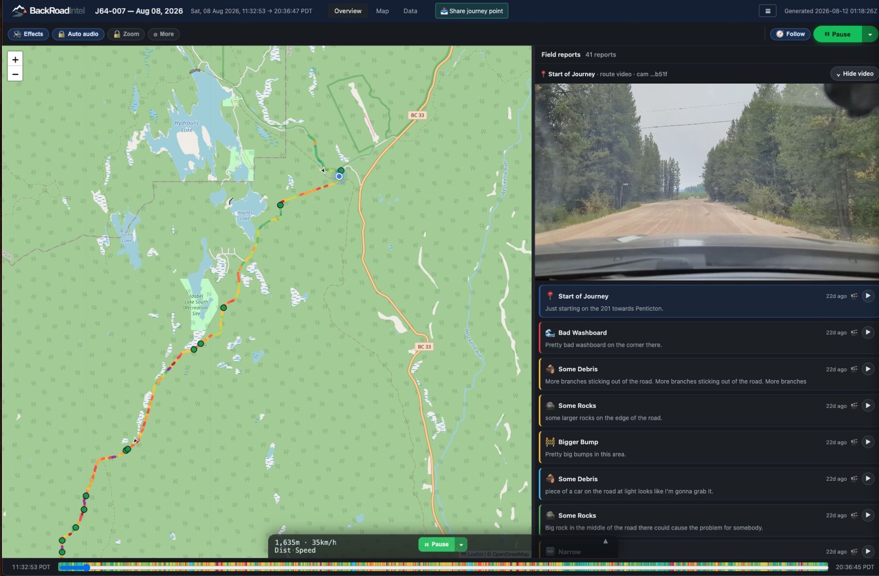 1:06 · real drive · sound on
You own more corridor than you can visit.
Inspection is mandatory. Rights-of-way, patrols, haul roads, dam access, the obligations exist whether or not the capacity does.
Contractors invoice; nobody verifies. Brushing, grading, clearing and repairs are proven by paperwork and a photo somebody chose to take.
The evidence question always comes. A regulator, an underwriter, a court or a council asks what you saw and when, and the answer lives in scattered field notes.
The same record. A different corridor.
Transmission corridor, pipeline corridor, access corridor, haul road corridor, the product doesn't change. The corridor type does. Open a sector for the full page.
Industry & energy
Private budgets, regulated inspection obligations, and contractors to verify.
Electrical utilitiesrights-of-way · access roads · stations
Know the condition of every right-of-way, access road and remote station you own.
Corridor programs are among your largest maintenance lines, and the evidence lives in scattered field notes.
Open the utilities page →Walk the entire line from your desk. Tower condition and ground condition at every point, not a sample at intervals.
The same coordinates before and after the cycle. Brushing, grading, culvert clearing and fence repair verified independently of the invoice.
Know the road is passable before the crew leaves, not after the truck turns around.
Encroachment, washouts, erosion and fence damage surfaced on your interval, not only at the annual inspection.
Visible encroaching growth is flagged for follow-up. Clearance measurement stays with your aerial and LiDAR programs, that's a claim we don't make.
Water, sewer & drainagerenewals · restoration · utility cuts
The restoration promise is yours. The record of it should be too.
Your crews open the street, a contractor puts it back, and the complaint comes to you. A dated record of every street in the program, before the trench and after the sod.
Open the water & drainage page →Not a one-time survey of the block you expect trouble on. Every street in the program, dated, before the first truck mobilizes.
Open trench, temporary patch, the winter, permanent restoration, the sod the following spring. The same address, pass after pass.
Paving, curb and sod checked against the record rather than the invoice, inside the warranty period.
See the temporary patch still there in June and the settled edge at month twelve before the City or a resident does.
This doesn't replace the inspector, the pre-construction survey or CCTV. It is the record between them. We record the surface; we don't measure it.
Gas & pipelineROW patrols · crossings · encroachment
Your right-of-way patrols, permanently documented.
Patrols run weekly to monthly. The record is a paper form and a photo somebody chose to take.
Open the pipeline page →The whole ROW reviewable, not just the observation points someone stopped at.
Construction, excavation, staged equipment and ground disturbance in the right-of-way, on the record.
The conditions that change between passes, compared pass to pass.
GPS-tracked and timestamped, so the compliance file holds visual proof, not just a signature.
This strengthens your patrol documentation. We don't claim to satisfy a patrol requirement, that determination is yours and your regulator's.
Upstream & midstream energylease roads · wellsites · gathering lines
Know the condition of every lease road and site approach before the crew rolls.
Your access network is bigger than your inspection capacity.
Open the energy page →Passability, washouts, spring breakup damage and culverts, because a turned-back crew is a lost day.
Gathering lines and pipeline ROW, reviewable end to end.
Pads, gates, signage and fence lines at unmanned sites, captured on the drives already happening.
When you're proving a site was restored, a dated visual record is exactly what the file needs.
Mining & mineral extractionhaul roads · perimeters · TSF access
Every haul road, perimeter and access route, on one reviewable record.
You already inspect daily. Nothing keeps those inspections as something you can compare month over month.
Open the mining page →Surface, drainage, windrows and spillage, the same segment across dates, as it changes over days, weeks and months.
Long boundaries and multiple properties, covered on drives already happening.
Access roads, culverts, drains and visible erosion, on your weekly cadence.
Grading and road maintenance confirmed against the record, not the invoice.
A camera on a post sees one angle forever. A vehicle gets close to every section, at angles a fixed camera can't. Structural and geotechnical assessment stays with your engineers.
Public sector
Where evacuation routes and road health live, and where sponsorship can carry the cost when budgets can't.
Emergency managementevacuation corridors · readiness · seasons
Whether the routes out are passable, on the record before the season.
A dedicated evacuation-readiness program built on the same corridor record — with seasonal coverage that earns its keep all year.
Open the emergency page →Surface, culverts, bridge approaches and choke points along the routes out, documented ahead of the season.
A dated baseline of egress passability, so risk is on the record before the event, not discovered during it.
The same corridor at the end of one season and before the next — degradation you can see, fund and act on.
Winter road-condition monitoring, everyday ambulance and responder access, extreme-weather readiness spring to fall.
A dedicated program with its own page, see Emergency & evacuation readiness and why the strain is rising.
Regional & county governmentsrural networks · road health · egress
A current condition record for every rural road you're responsible for.
Your network is measured in hundreds of kilometres and inspected by complaint.
Open the regional page →Surface, drainage, culverts and shoulders across the whole network, not just the segments someone reported.
Visible change between engineering inspections.
Dated evidence of what the condition actually was, which cuts both ways, and that's exactly why you want it.
A visual record of deterioration makes a stronger funding application than an estimate alone.
Regional road monitoring lives here. Evacuation & egress readiness is a dedicated program, see Emergency & evacuation.
First Nations communitiesterritory · egress · agreements · advocacy
Your territory's ground truth, held by the community.
A permanent record of conditions across your territory, roads, corridors, land, as they change over time. The community holds the record. Not the proponent, not the ministry.
Open the communities page →Whether the routes out are passable, documented before fire season, not during it.
Roads, corridors and infrastructure covered by impact-benefit or revenue-sharing agreements, verify condition without fielding a crew.
Condition records for the routes people depend on in high-risk terrain.
A dated visual record for funders, proponents and government tables, so the ask is documentation, not description.
This is where BackRoadIntel started, active deployments with communities across British Columbia.
Towns & municipalitiesroad health · contracts · egress
Your road network, on the record.
Open the municipal page →Surface and culvert condition across town, on a cadence.
Paving, patching and snow contracts confirmed against the record.
Every cut a utility makes in a town street, on the record at the patch, the permanent restoration and the warranty year, findable by address when the sunken-patch complaint comes in.
Evacuation route condition, documented ahead of the season.
Land & recreation
Smaller networks, mostly access and fence line, where the capture kit is usually the right fit.
Parks & resortsaccess roads · trails · seasonal opening
Access and trail corridors, season over season.
Open the parks page →What's passable now versus after melt, before guests and staff find out the hard way.
A dated record of trail and service corridor condition, compared year to year.
Fence lines and gates covered on drives already happening.
Private landownersranch & forestry roads · fence lines
Your roads, fences and gates, on a record you own.
Open the landowner page →Ranch and forestry roads, fence lines and gates, documented over time.
Dated proof of third-party damage on routes you share.
The same place, three passes apart.
Kilometre 4.5 of an access road, from the same point on each pass, with the rainfall between them — the whole product in one row.
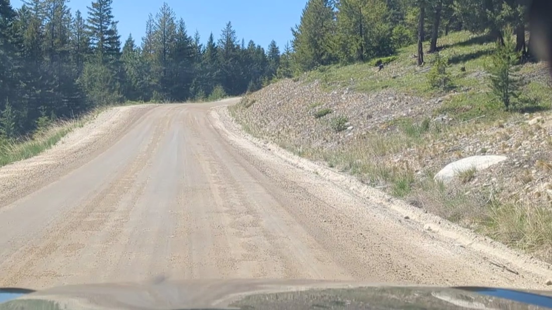
Graded, drains, no defects.
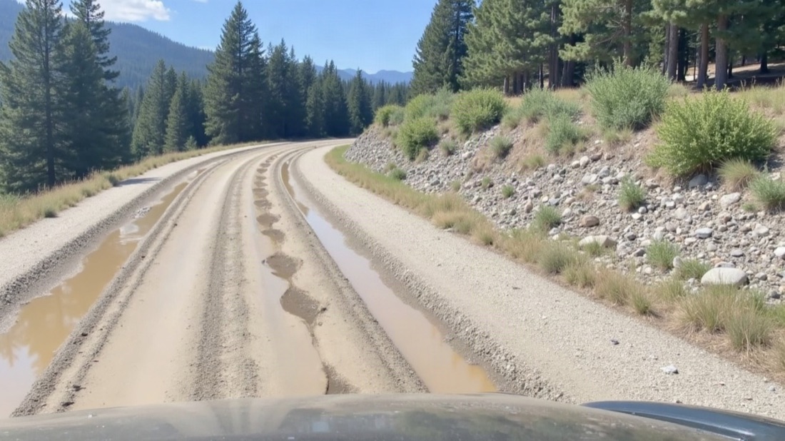
Potholes and runoff in the tracks, shoulder starting to go. Grade it now, before it compounds.
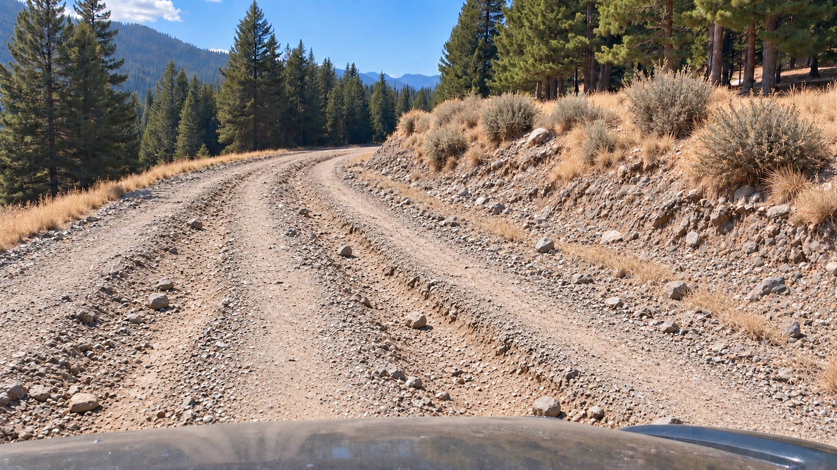
Degraded surface — loose rock, ruts and washboard, many hazards. Now it's a rebuild.
Illustrative prototype. Production records open as hosted, view-only pages on a phone, no login.
Your record, in the driver’s own words.
The driver taps once and talks. It is the same device that is recording the video — the Dashcam unit in the kit — so the audio and the footage are one capture. The voice note is saved with the moment it was spoken — the point on the route, the time, the speed, the heading — then transcribed, titled and filed into the record at the place it happened. A form field gives you a category. A voice gives you what the person actually saw.
“There’s a car in the ditch on this road.”
“It looks like smoke coming from the forest area on the right — but I’m not sure.”
“Some rocks that just formed on the road here, we gotta take care of.”
“There’s some equipment in the field on the left that looks out of place. Checking in on it.”
Two of those aren’t certain, and that is deliberate. “I’m not sure” is a legitimate entry. The record keeps the doubt exactly as it was spoken rather than rounding it into a category — and the next pass over that spot is what settles it.
Tap to talk on the Dashcam device — the same unit recording the video. Hands stay on the wheel, and the note is attached to the metre it was spoken at rather than typed up from memory hours later. A photo is tapped the same way.
Every voice note becomes searchable text automatically, so a season of drives is something you can read through and search, not a pile of audio somebody has to sit and listen to.
The transcript is read for what it describes — rock, water, debris, wildlife, a bridge, a washout — and dropped on the map as a titled field report you can filter and pull into a report.
The Dashcam device records the same way on the windshield mount or in somebody’s hand. A culvert you stop and walk down to, a slide you get out to look at, a site you cross on foot — spoken, located and filed into the record exactly like the kilometre you drove past.
The people driving those routes already know things your record doesn’t: which culvert backs up, what that slope did last spring, which stretch never holds after a grade. That knowledge normally lives in somebody’s head and goes with them when they move on. Spoken into the record, it stays with the asset.
“Watch this area for rock slides going forward.” Sometimes the driver isn’t reporting today’s condition — they’re asking for the next drive to check something. With the watch option, a spoken note sets a watch from the driver’s seat, named and located as it’s said, then answered on every drive that covers it from then on. No form, no desk, nobody to ask. It is the fastest way a standing question should ever get created — out loud, at the spot, by the person who noticed.
Voice capture, automatic transcription and hazard tagging run in the Scout app and platform today. The four notes above are written as examples — the wording is ours, the format is what a real annotation looks like. Watches, including setting one by voice, are offered as an option on the program.
Set a watch. The record does the noticing.
A field report belongs to the drive it was tapped on. A watch is where a standing question goes instead — attached to a thing or a place, and answered on every drive that covers it.
A watched asset
A tree, a tower, a culvert, a gate. Named, located, and reported on every time a drive covers it.
A watched zone
A stretch of corridor where a kind of problem keeps happening. Named for the problem, not the kilometre — because that's how the crew already talks about it.
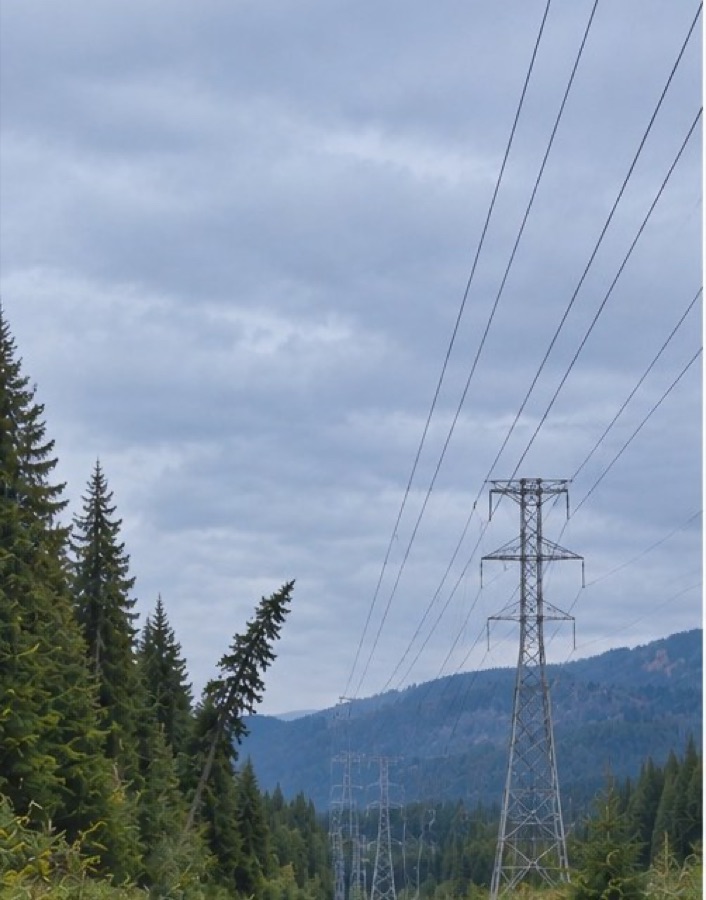
Slight lean toward the line. Nothing to do — but now it's a named thing with a question attached.
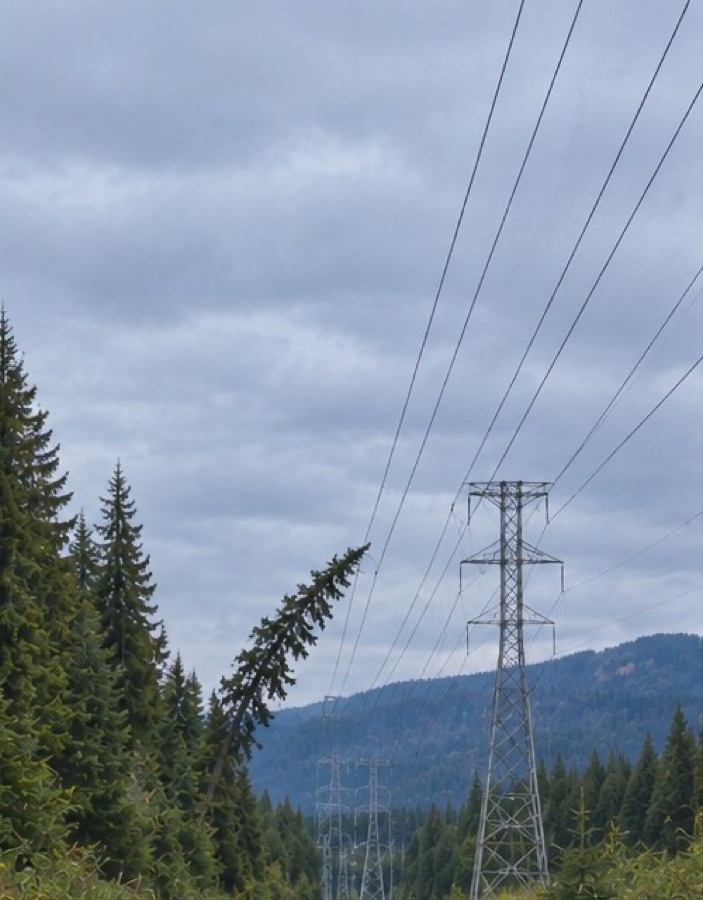
The lean has increased. An email goes out the day the record is published.
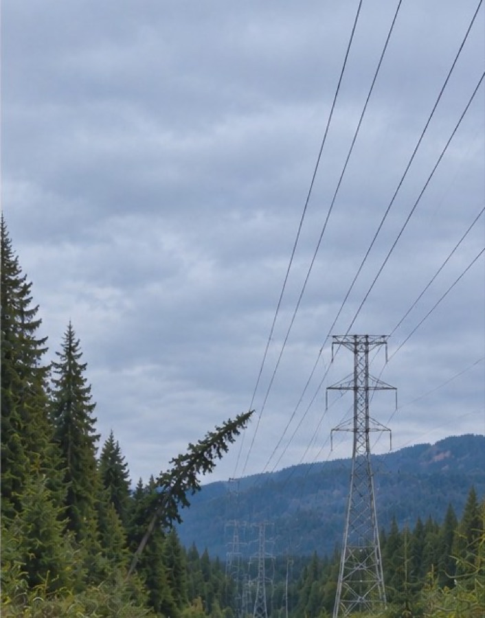
The crown has reached the conductors. This is now a crew and a date, not a discussion.
The three frames above are an illustration — a worked example of how a watch behaves over successive drives, not a captured record from a customer corridor. The box doesn't move. A watch is set on a place, and what changes is what stands inside it. Nobody walked this line — a vehicle drove past three times on scheduled passes, and the record did the noticing.
| Watch | Scope | Answers | Last event |
|---|---|---|---|
| Watch — Leaning tree | AssetHigh Valley ROW · km 4.6 | Has the lean increased, or has it come down? | 15 Jul · fired |
| Watch — Tower 25 | AssetMount Phoenix west · km 9.1 | Condition of the structure and its access track each drive. | 15 Jul · quiet |
| Watch — Common pothole zone | ZoneAccess road · km 2.1–3.4 | Any point dropping two levels or more. | 15 Jul · fired |
| Watch — Common water hazard | ZoneHigh Valley ROW · km 6.5–7.4 | Standing water, a new washout flag, or an improvement of three levels or more. | 16 Jul · fired |
| Watch — Common rock slide zone | ZoneMount Phoenix west · km 11.8–12.6 | New debris on the running surface after a storm or freeze-thaw. | quiet since Apr |
| Watch — Fence damage zone | ZoneSubstation perimeter | Any change along the fence run — leaning posts, breaches, vegetation load. | quiet since Apr |
Illustrative. In production, a fired watch emails the owner the day the record is published.
A drive becomes a record.
A vehicle drives the corridor, continuous video, GPS and impact sensing, plus a tap to flag anything the driver sees.
We turn the drive into a reviewable record tied to the map, with conditions and hazards identified.
Scroll the corridor from your desk. Compare passes. Pull out the evidence you need.
Buy the record, or buy the kit.
We capture it
A done-for-you asset corridor report on your interval — monthly, quarterly, or per project. No subscription.
Your fleet captures it
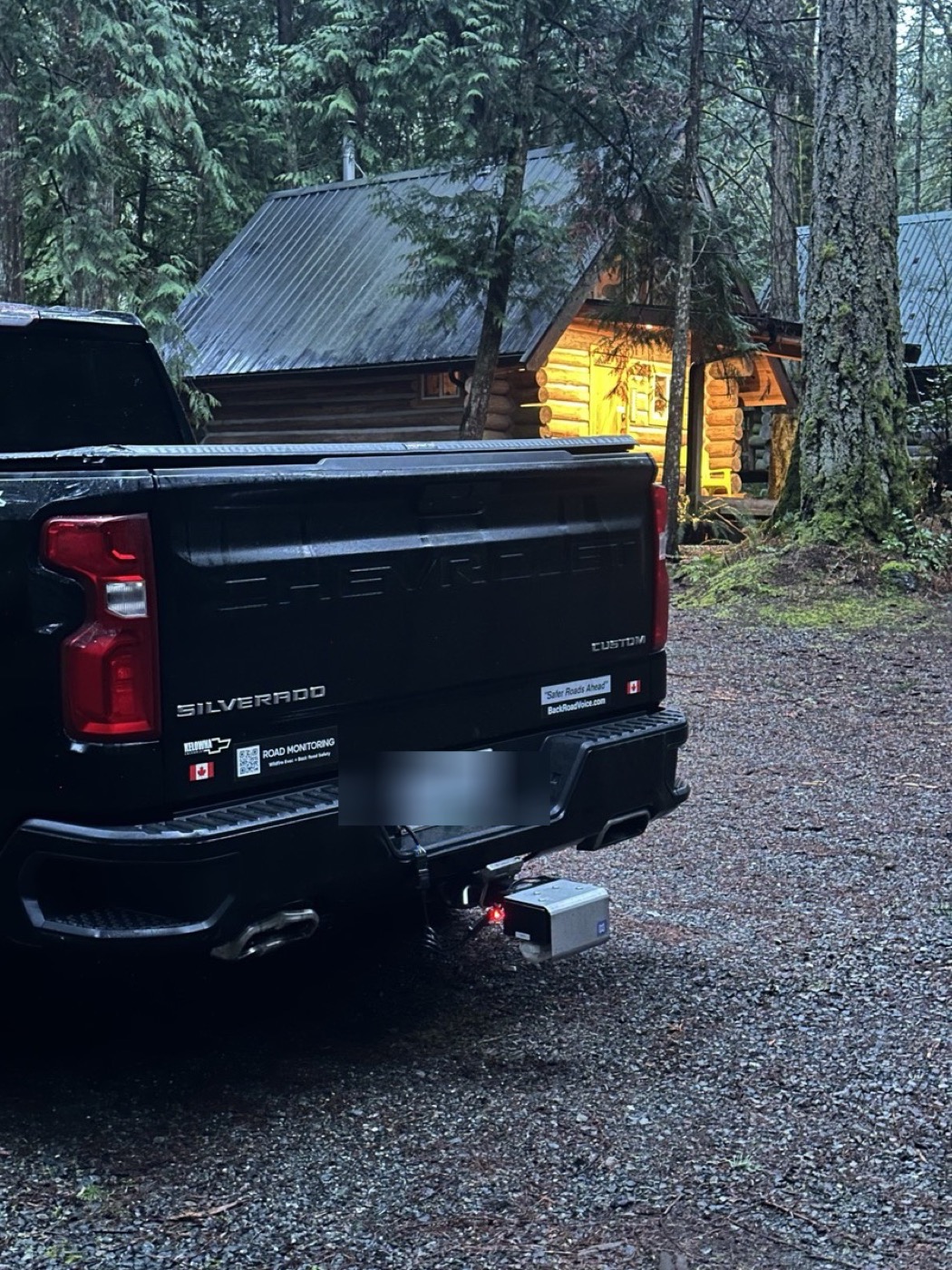
A capture kit in your own vehicles turns drives already happening into your records — unlimited roads on one device.
If you already have vehicles on those routes, the kit is cheaper. If you don't, don't build a program, buy the record. Either way it sits under one manager's signing authority: no procurement cycle.
Also from BackRoadIntel
Public-sector programs built on the same record.
Where evacuation routes and rural road health live. Regional road monitoring runs under the regional & county program; evacuation and egress readiness is a dedicated offering we're bringing back online.
The limits, out loud.
From a wildfire evacuation to a mapping company.
When the fire jumped the lake, founder Ryan Gallagher scrambled to work out which forest service roads he could get out on. That's why BackRoadIntel exists — read the story, meet the team, and see our coverage.
One pass is a snapshot. Repeated passes are a history, and history can't be recreated after the fact.
The earlier the record starts, the more it's worth. Tell us which corridor you'd document first.